MyTopo
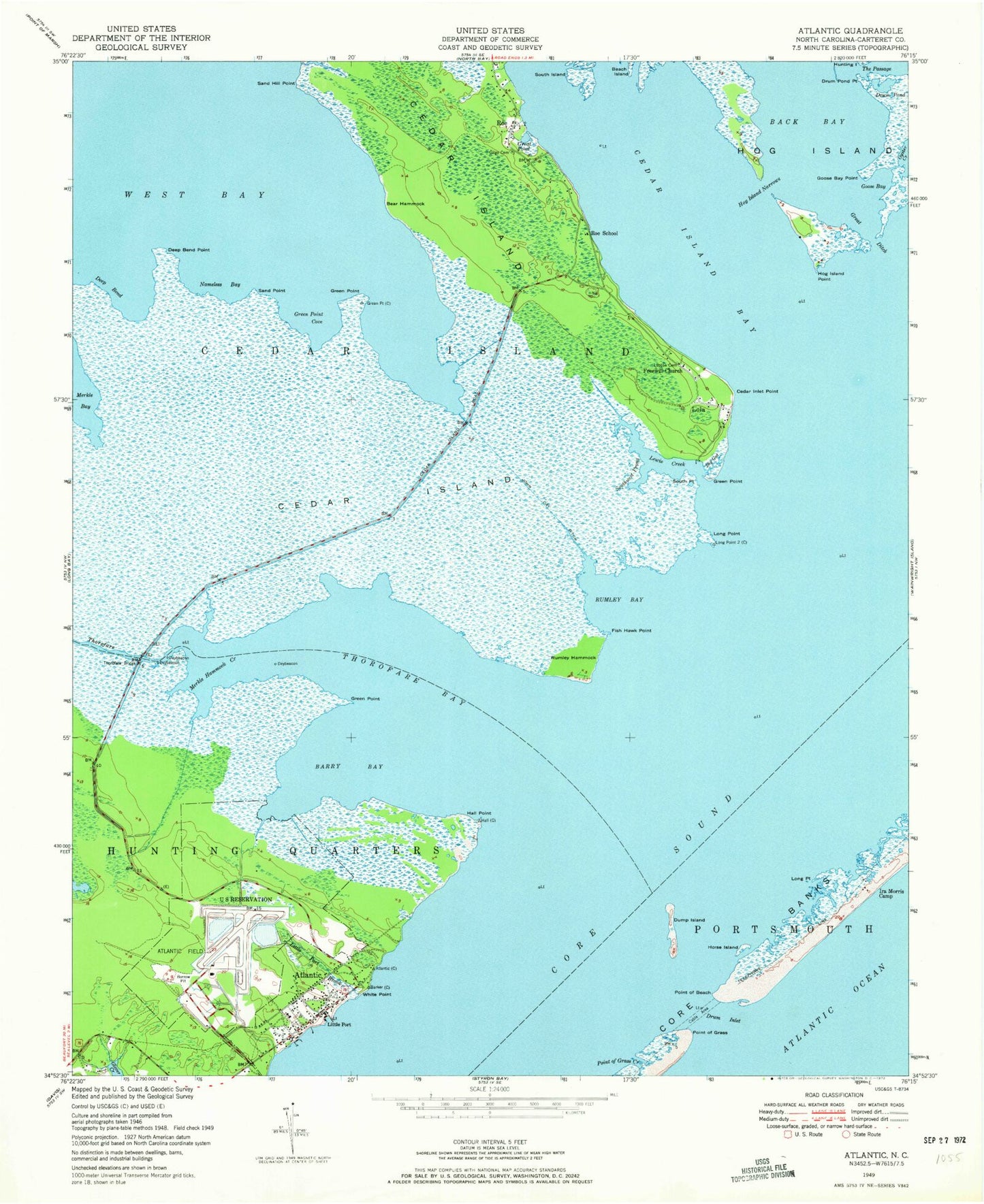
Classic USGS Atlantic North Carolina 7.5'x7.5' Topo Map
Couldn't load pickup availability
Historical USGS topographic quad map of Atlantic in the state of North Carolina. Map scale may vary for some years, but is generally around 1:24,000. Print size is approximately 24" x 27"
This quadrangle is in the following counties: Carteret.
The map contains contour lines, roads, rivers, towns, and lakes. Printed on high-quality waterproof paper with UV fade-resistant inks, and shipped rolled.
Contains the following named places: Atlantic, Atlantic Cemetery, Atlantic Census Designated Place, Atlantic Field Marine Corps Outlying Field, Atlantic Fire Department, Atlantic Post Office, Atlantic School, Back Bay, Barry Bay, Bear Hammock, Big Gut, Cedar Island, Cedar Island Bay, Cedar Island National Wildlife Refuge, Cedar Island National Wildlife Refuge Headquarters, Cedar Island Point, Cedar Island Volunteer Fire Department, Deep Bend, Deep Bend Point, Drum Inlet, Drum Pond, Drum Pond Point, Dump Island, Fish Hawk Point, Freewill Church, Gilgo Cemetery, Goose Bay, Goose Bay Point, Great Ditch, Great Pond, Green Point, Green Point Cove, Hall Point, Hog Island Narrows, Hog Island Point, Horse Island, Ira Morris Camp, Jackson Private Airport, John Ditch, Lewis Creek, Little Port, Little Port Brook, Lola, Long Point, Lookout Point, Lupton, Lupton Cemetery, Merkle Hammock Creek, Morris Marina, Nameless Bay, Old Drum Inlet, Point of Beach, Point of Grass, Point of Grass Creek, Roe, Roe School, Rumley Bay, Rumley Hammock, Sand Hill Point, Sand Point, South Island, South Point, Southwest Prong, The Passage, Thorofare, Thorofare Bay, Thorofare Bridge, Township of Atlantic, White Point, Wolf's Den Airport, Wolves Den, ZIP Codes: 28511, 28520