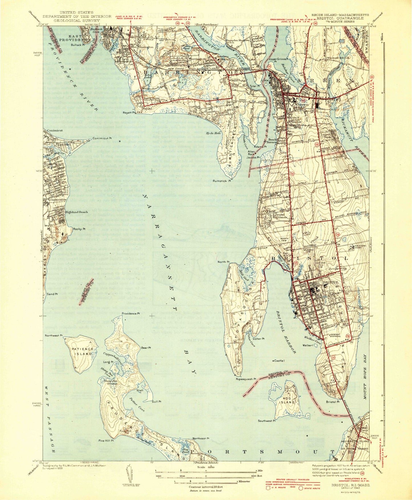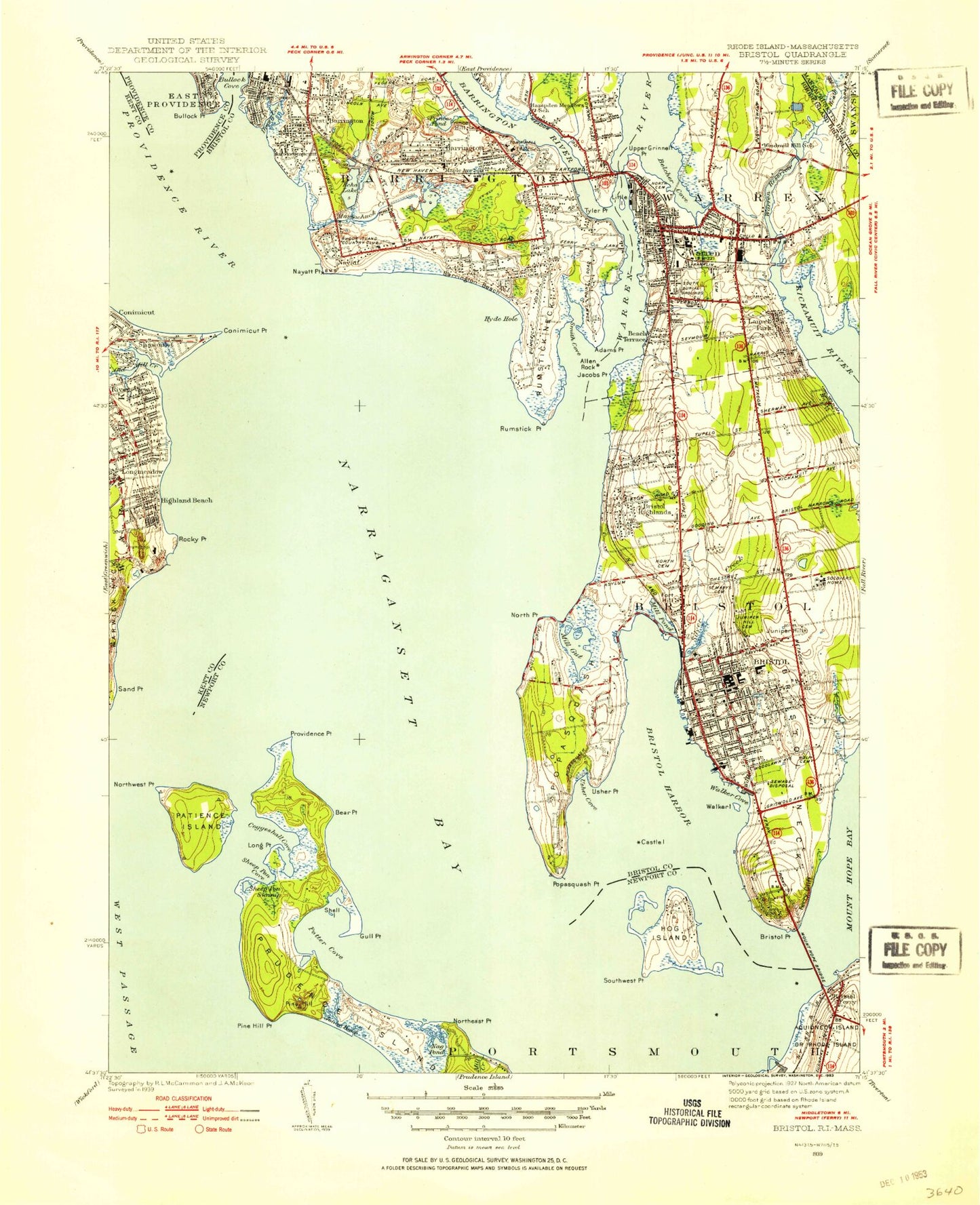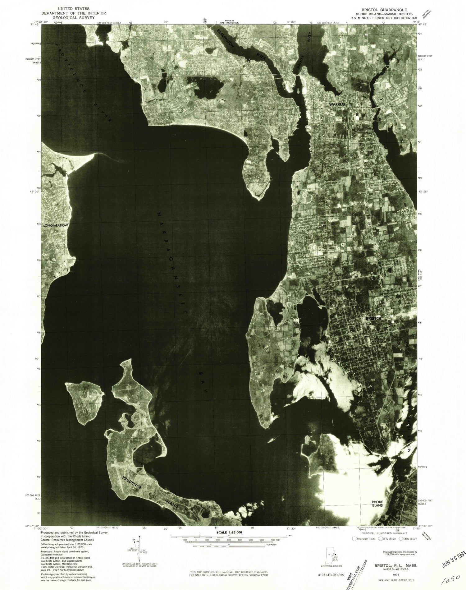
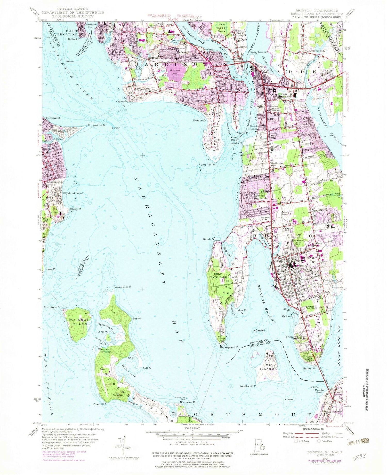

MyTopo
Classic USGS Bristol Rhode Island 7.5'x7.5' Topo Map
Couldn't load pickup availability
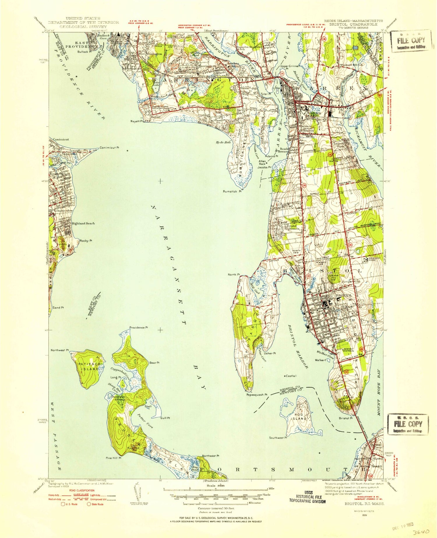
Historical USGS topographic quad map of Bristol in the state of Rhode Island. Map scale is 1:25000. Print size is approximately 24" x 27"
This quadrangle is in the following counties: Bristol, Kent, Newport, Providence.
The map contains contour lines, roads, rivers, towns, and lakes. Printed on high-quality waterproof paper with UV fade-resistant inks, and shipped rolled.
Contains the following named places: Adams Point, Allen Ledge, Allen Neck, Allen Rock, Americas Cup Hall of Fame, Annawomscutt, Annawomscutt Brook, Assembly of God Church, Baptist Church of Warren, Barden Rock, Barren Ledge, Barrington, Barrington Beach, Barrington Bridge, Barrington Civic Center Historic District, Barrington Community Center, Barrington High School, Barrington Middle School, Barrington Post Office, Barrington Presbyterian Church, Barrington Preservation Society Museum, Barrington Public Library, Barrington River, Barrington Town Hall, Barrington United Methodist Church, Barrington Yacht Club, Bay Spring, Beach Terrace, Bear Point, Belcher Cove, Blackstone Rock, Blithewold Mansion and Gardens, Boystown Fly-in-Ranch (historical), Brickyard Pond, Bristol, Bristol County, Bristol County Courthouse, Bristol County Jail, Bristol Customhouse, Bristol Ferry, Bristol Ferry, Bristol Ferry Lighthouse (historical), Bristol Golf Club, Bristol Harbor, Bristol Highlands, Bristol Historical and Preservation Society Library, Bristol Historical and Preservation Society Museum, Bristol Neck, Bristol Playground, Bristol Point, Bristol Post Office, Bristol Shopping Center, Bristol State House Foundation, Bristol Town Beach, Bristol Town Common, Bristol Township, Bristol Waterfront Historic District, Bristol Yacht Club, Bullock Point, Bullock Point Reach, Bullocks Point Light, Burnside Memorial Building, Burr Hill, Byfield School, Carmelite Monastery, Carousel Nursery, Castle Island, Chapin Memorial Chapel, Charles W Greene Museum, Child Street School, Church of the Holy Spirit, Coggeshall Cove, Coggeshall Farm Museum, Colt State Park, Colt-Andrews School, Conimicut Lighthouse, Conimicut Point, Conimicut Point Reach, Crescent Park, Deep Hole, Deyer Rock, Drown Cove, East Burial Ground, East Warren, Echo Lake, Entrance Channel, Fairlawn Golf Course, Ferry Cliff, Ferry Hill, Firemans Museum, First Congregational Church, First United Methodist Church of Warren, Fork Rocks, Fort Hill, Fox Hill, Freedom Road Baptist Church, George Haile Free Library, George T Baker School (historical), Guiteras School, Gull Point, Halfmile Hill, Hampden Meadows School, Heath Brook, Herreshoff Marine Museum, Highland Beach, Hog Island, Holy Angels Church Education Center, Holy Angels Roman Catholic Church, Hope Street Shopping Center, Hugh Cole School, Hyde Hole, Jacobs Point, James Maxwell House Museum, Jenny Pond, Johnson Ledge, Juniper Hill, Juniper Hill Cemetery, Kelleys Ferry, Kickemuit Middle School, Kids Quarters Pre-School, Kings Kids Elementary School, Laurel Park, Leander Peck Memorial School, Linden Place Museum, Little Island, Little Peoples Nursery, Long Point, Longmeadow, Longmeadow Rock, Main Street School, Maple Avenue School, Martins Ferry (historical), Maxfields Corner, Middle Ground, Mill Gut, Mill Pond, Mount Hope Bridge, Mount Hope High School, Mount Tom Rock, Mussachuck Creek, Musselbed Shoals, Nag Pond, Narragansett Brick Works (historical), Nayatt, Nayatt House (historical), Nayatt Landing, Nayatt Point, Nayatt School, New Hope Christian Church, North Burial Ground, North Point, Northeast Point, Northwest Point, Nyatt Hall, Ocean State Plaza Shopping Center, Ohio Ledge, Old Mill Creek, Oliver School, Our Lady of Mount Carmel Church, Our Lady of Mount Carmel Convent, Our Lady of Mount Carmel School, Palmer River, Patience Island, Peck Center Playground, Penivs Rock, Phebes Neck, Pine Hill, Pine Hill ledge, Pine Hill Ledge, Pine Hill Point, Pomham Rocks Island, Popasquash Neck, Popasquash Point, Potter Cove, Prince Hill, Prince Pond, Prince's Hill Burial Ground, Providence Point, Prudence Island Ferry, Raggedy Ann Nursery School, Reynolds School, Rhode Island Country Club, Rhode Island Soldiers Home, River View, Rockwell Park, Rockwell School, Rocky Point, Rocky Point, Roger Williams University, Roger Williams University Library, Rogers Free Library, Rumstick Ledge, Rumstick Neck, Rumstick Neck Reach, Rumstick Point, Rumstick Rock, Rumstick Shoal, Saint Alexanders Roman Catholic Church, Saint Andrews School, Saint Casimirs Roman Catholic Church, Saint Columbans Seminary, Saint Elizabeths Church, Saint Elizabeths School, Saint Jean Baptiste Roman Catholic Church, Saint Johns Episcopal Church, Saint Marks Episcopal Church, Saint Mary of the Bay Roman Catholic Church, Sand Point, Sheep Pen Cove, Sheep Pen Swamp, Shell Island, Silver Creek, Smith Cove, Southwest Point, The Brothers, The Brothers, Town of Barrington, Town of Bristol, Town of Warren, Tree Point Rocks, Tyler Point, Upper Grinnell Point, Upper Middle Ground, Usher Cove, Usher Point, Usher Rocks, Walker Cove, Walker Creek, Walker Island, Warren, Warren Reservoir, Warren Reservoir Lower Dam, Warren Reservoir Upper, Warren Reservoir Upper Dam, Warren River, West Barrington