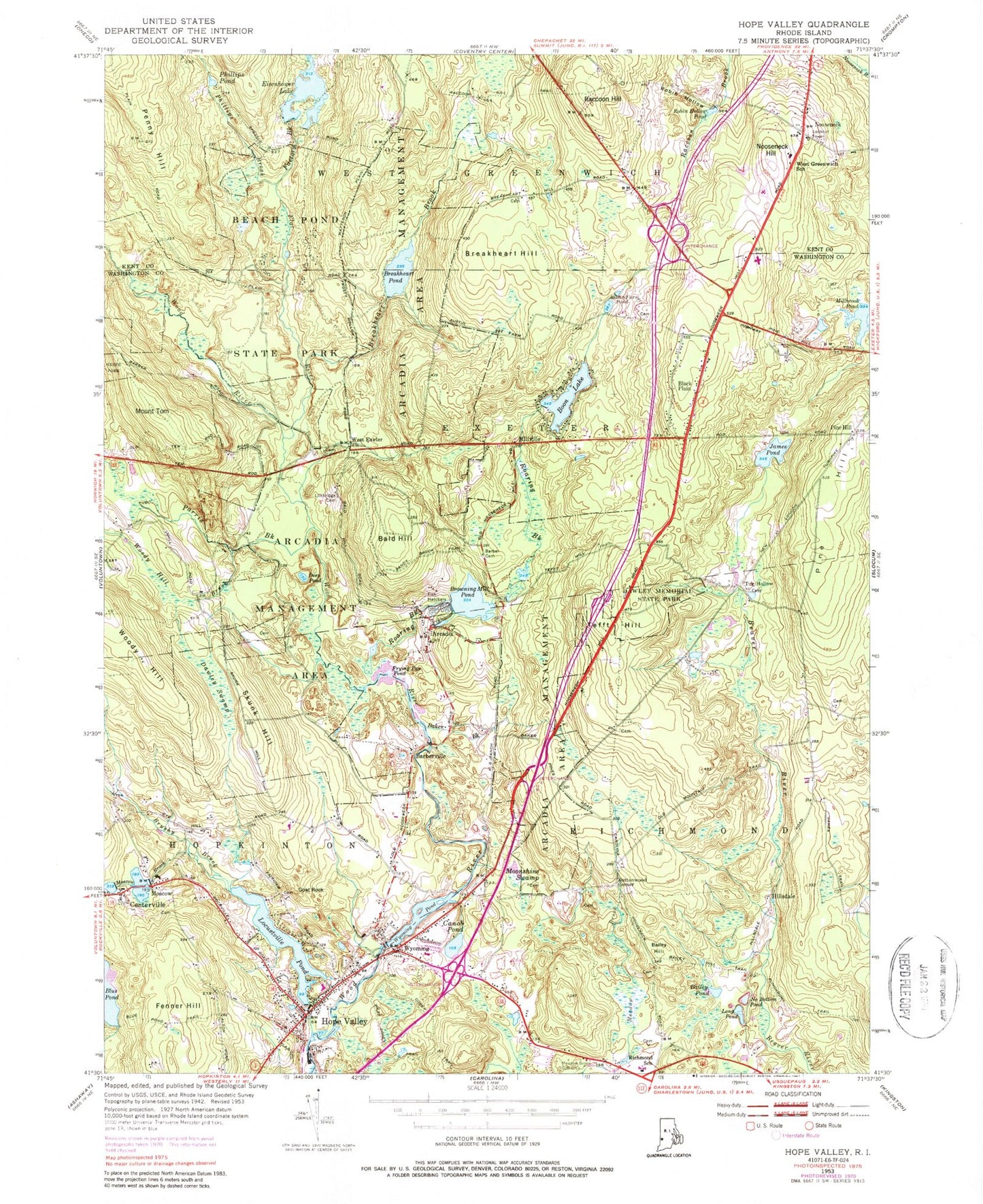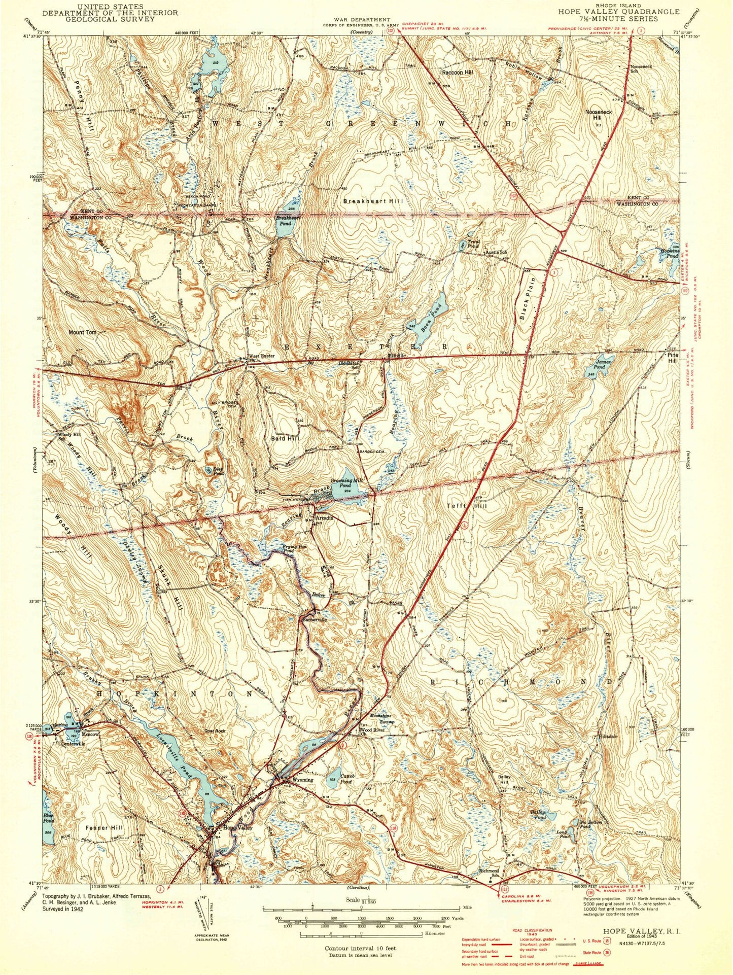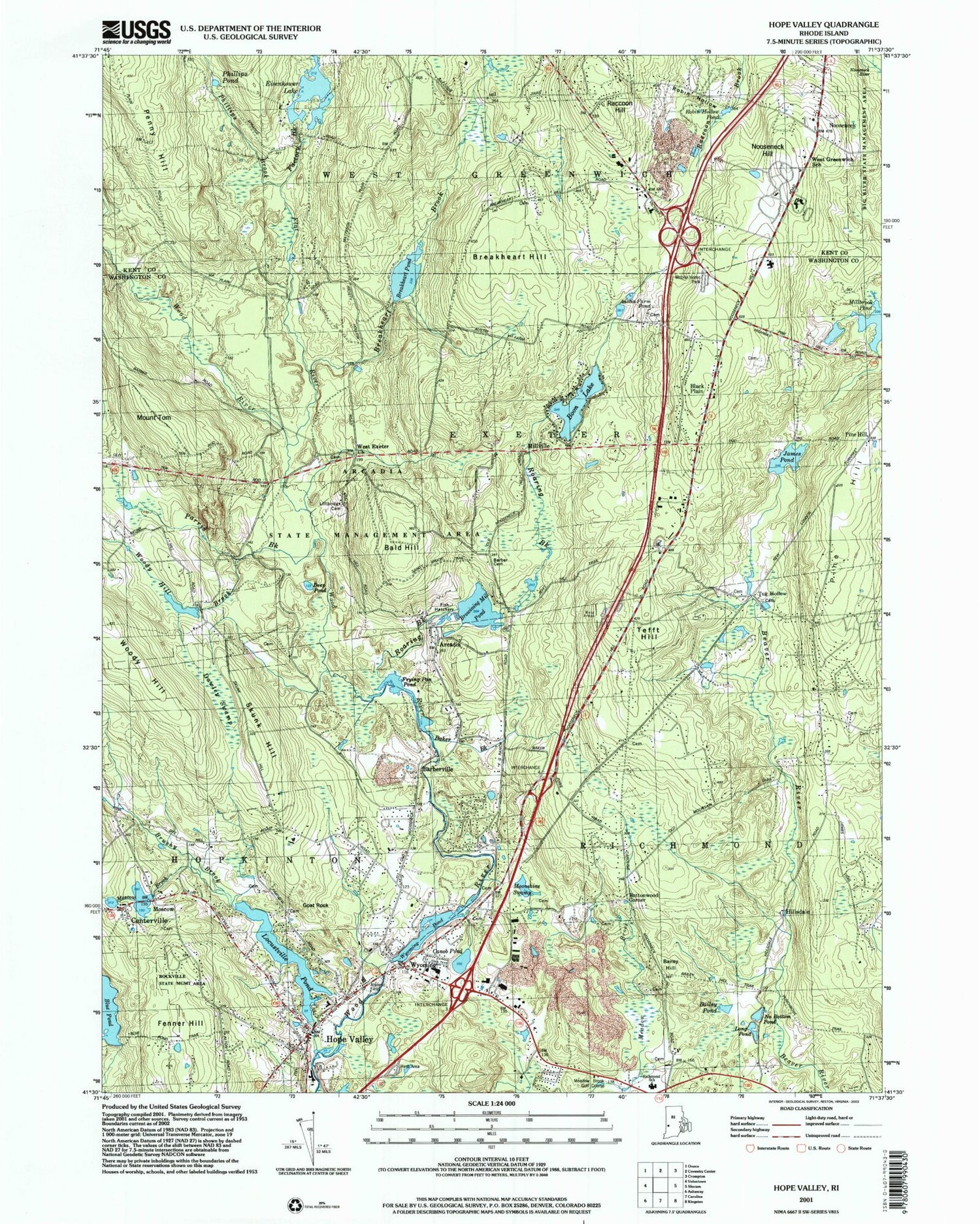
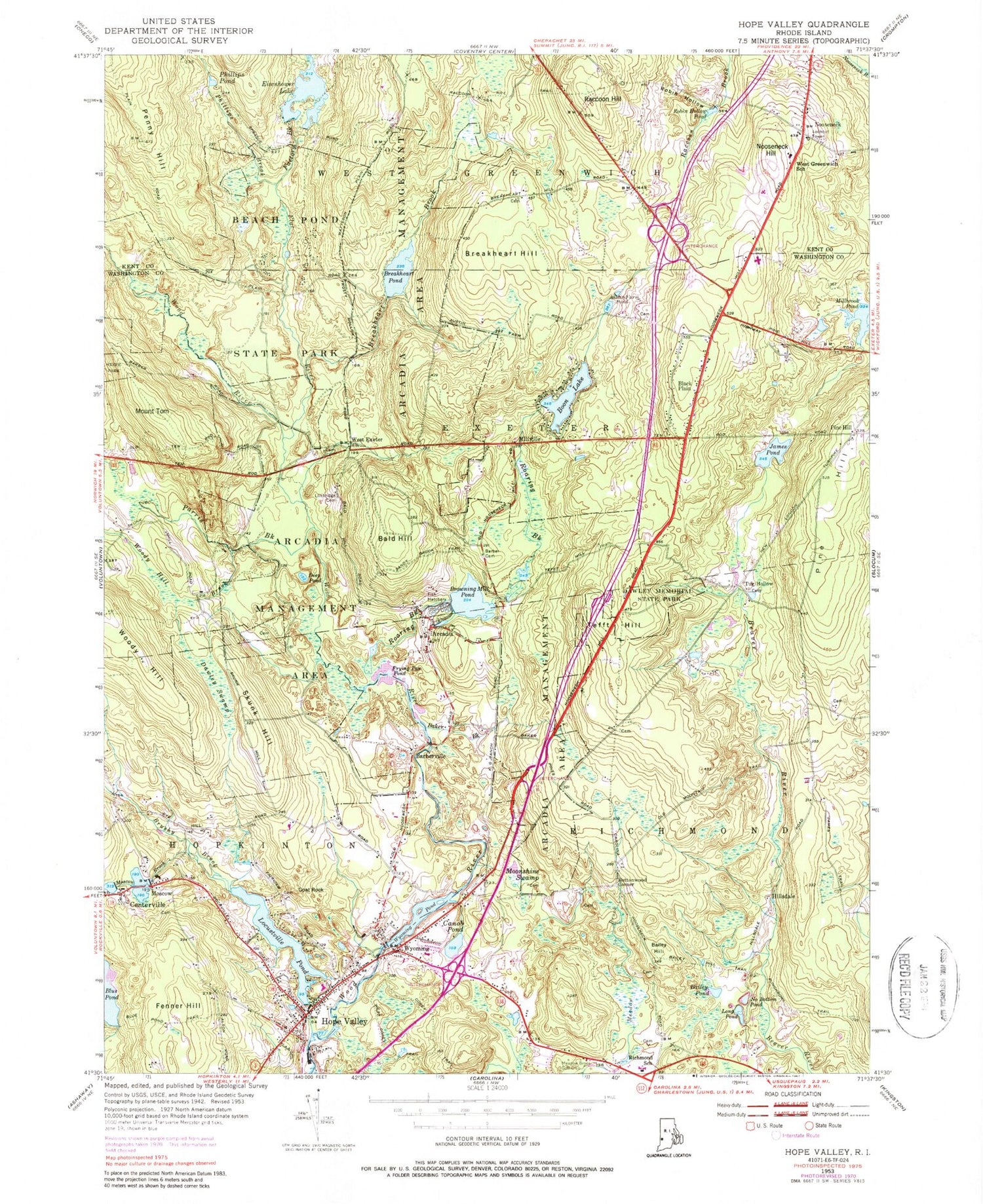
MyTopo
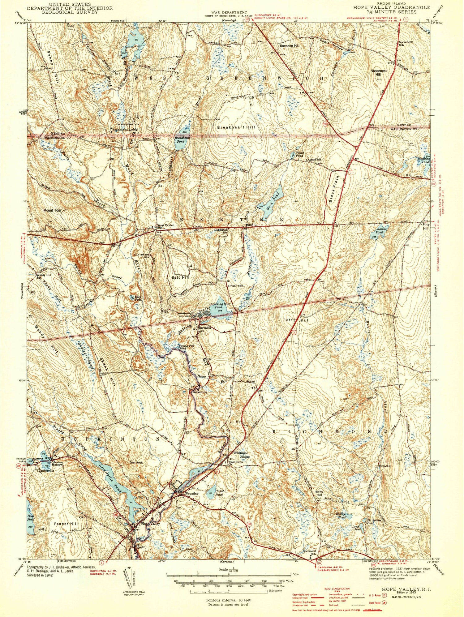
Classic USGS Hope Valley Rhode Island 7.5'x7.5' Topo Map
Couldn't load pickup availability
Historical USGS topographic quad map of Hope Valley in the state of Rhode Island. Typical map scale is 1:24,000, but may vary for certain years, if available. Print size: 24" x 27"
This quadrangle is in the following counties: Kent, Washington.
The map contains contour lines, roads, rivers, towns, and lakes. Printed on high-quality waterproof paper with UV fade-resistant inks, and shipped rolled.
Contains the following named places: Fenner Hill, Hope Valley, Moscow Brook, Moscow, Centerville, Brushy Brook, Goat Rock, Locustville Pond, Wyoming, Canob Pond, Moonshine Swamp, Bailey Pond, Long Pond, No Bottom Pond, Hillsdale, Woody Hill, Dawley Swamp, Skunk Hill, Frying Pan Pond, Roaring Brook, Browning Mill Pond, Baker Brook, Barberville, Tefft Hill, Woody Hill Brook, Parris Brook, Deep Pond, Bald Hill, Millville, James Pond, Mount Tom, Flat River, Phillips Brook, Phillips Pond, Eisenhower Lake, Factory Brook, Breakheart Brook, Breakheart Pond, Breakheart Hill, Wyoming Pond, Raccoon Hill, Austin Farm Pond, Boon Lake, Black Plain, Nooseneck Hill, Robin Hollow, Robin Hollow Pond, Millbrook Pond, Buttonwood Corner, Bailey Hill, Nooseneck, Blue Pond Dam, Locustville Pond Dam, Wyoming Pond Upper Dam, Browning Mill Pond Dam, Mount Tom Club Wildlife Marsh, Mount Tom Club Wildlife Marsh Dam, Boone Lake, Boone Lake Dam, Breakheart Pond Dam, Eisenhower Lake Dam, Locustville, Arcadia, Gates Pond, Tug Hollow, Pine Hill, Town of Exeter, Arcadia Management Area, Peleg Arnold Lot Cemetery, Austin, Ezekiel Austin Lot Cemetery, Austin School (historical), Avis Barber Lot Cemetery, Moses Barber Lot Cemetery, Tefft Barber Lot Cemetery, Daniel Barber Lot Cemetery, Barber Plot, Beach Pond Forest Environment Site, Bell Schoolhouse (historical), Bitgood Plot, Judge William Bliven Lot Cemetery, Boone Family Lot Cemetery, Browning Mill Pond Area Beach, Alpheus Burdick Lot Cemetery, Carpenter Lot Cemetery, Cezar Onion Lot Cemetery, Dawley Memorial State Park, Hope Valley Elementary School, Hope Valley Post Office, Joseph James Lot Cemetery, Job Kenyon Lot Cemetery, Benjamin Kinyon Lot Cemetery, Langworthy Public Library, Larkin Plot, Lewis City, John Lewis Lot Cemetery, Thomas Lewis Lot Cemetery, Captain Stephen Lewis Lot Cemetery, Lewis - Himes - Tillinghast Plot, Captain Reynolds Lillibridge Lot Cemetery, Gardiner Lillibridge Lot Cemetery, Whitman Lillibridge Lot Cemetery, Johnathan Lillibridge Lot Cemetery, Oliver Lockwood Lot Cemetery, Locustville Pond Public Fishing Area, Meadow Brook Golf Club, Metcalf School, New Hope Chapel, Perkins Family Lot Cemetery, Perkins Lot Cemetery, Pine Grove Cemetery, Pine Grove Cemetery, Richmond Elementary School, Richmond Family Lot Cemetery, Richmond Town Hall, Robert Browning Lot Cemetery, Saint Josephs Chapel Roman Catholic Church, James Sheldon Lot Cemetery, Smith Lot Cemetery, Straight Plot, Sprague Tefft Lot Cemetery, Thomas Wilcox Lot Cemetery, Tomaquag Indian Museum, West Exeter Church, Willcox - Tate Lot Cemetery, Wyoming Post Office, Wyoming Village Historic District, Woodmansee Plot, Exeter-Greenwich Regional Junior High School, Exeter-West Greenwich Regional High School, Mildred E Lineham School, Rockville State Management Area, Hope Valley Census Designated Place, Camp E-Hun-Tee, Exeter Fire Department 2 Station 2, Rhode Island State Police Hope Valley Barracks, Hope Valley - Wyoming Fire District Station 1, Richmond Police Department, Wee Care Day Care Center, West Greenwich Fire and Rescue Station 2, Meadowbrood Waldorf School, Nuweetooun School, Moscow Ponds, Wyoming Census Designated Place, Carolina Fire District Station 3, Richmond - Carolina Fire District Station 2, West Greenwich Rescue Squad, Hope Valley Ambulance Squad, Saint Joseph's Cemetery, Thomas Hall Lot Cemetery, Stafford Greene Lot Cemetery, Joseph Nichols Lot, Joseph Hoxie Lot, David Hall Lot Cemetery, Clark Franklin Lot Cemetery, Clemens Lot, Ellis Lot Cemetery, Gideon Ellis Lot Cemetery, Andrew Edward Lot, Caleb Bailey Lot Cemetery, Historical Cemetery 59, Jacob Lewis Lot Cemetery, Warner Lot Cemetery, Clark Lewis Lot Cemetery, Fenner Hill, Hope Valley, Moscow Brook, Moscow, Centerville, Brushy Brook, Goat Rock, Locustville Pond, Wyoming, Canob Pond, Moonshine Swamp, Bailey Pond, Long Pond, No Bottom Pond, Hillsdale, Woody Hill, Dawley Swamp, Skunk Hill, Frying Pan Pond, Roaring Brook, Browning Mill Pond, Baker Brook, Barberville, Tefft Hill, Woody Hill Brook, Parris Brook, Deep Pond, Bald Hill, Millville, James Pond, Mount Tom, Flat River, Phillips Brook, Phillips Pond, Eisenhower Lake, Factory Brook, Breakheart Brook, Breakheart Pond, Breakheart Hill, Wyoming Pond, Raccoon Hill, Austin Farm Pond, Boon Lake, Black Plain, Nooseneck Hill, Robin Hollow, Robin Hollow Pond, Millbrook Pond, Buttonwood Corner, Bailey Hill, Nooseneck, Blue Pond Dam, Locustville Pond Dam, Wyoming Pond Upper Dam, Browning Mill Pond Dam, Mount Tom Club Wildlife Marsh, Mount Tom Club Wildlife Marsh Dam, Boone Lake, Boone Lake Dam, Breakheart Pond Dam, Eisenhower Lake Dam, Locustville, Arcadia, Gates Pond, Tug Hollow, Pine Hill, Town of Exeter, Arcadia Management Area, Peleg Arnold Lot Cemetery, Austin, Ezekiel Austin Lot Cemetery, Austin School (historical)